The second day of our trip to Petersburg consisted of driving the 33 mile road which basically follows the earthwork lines of the opposing forces all the way to the Five Forks Battlefield, the western most site which is part of the park. Along the way we passed the remains of a number of trenches, embankments, and forts.
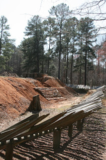
The picture above is of a site which was known as Fort Fisher. It was the largest earthwork fortification on the Petersburg front. On April 2, 1865 Union forces assaulted the Confederate lines just west of Fort Fisher and achieved a breakthrough.
Just to the southeast of Fort Fisher is the Poplar Grove National Cemetery which was established in 1866 for Union soldiers who died during the Petersburg and Appomattox campaigns. It is the location of the Western Front Visitors Center which is open only during the summer.
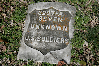
As fate would have it, when we reached the Five Forks Battlefield Visitors Center the ranger at that location is assigned to Poplar Grove during the summer. She had some great stories about the cemetery. One of the strangest has to do with the grave markers. Originally national cemeteries were under the supervision of the army, but in the 1930s they were transferred to the National Park Service. Funds were not forthcoming to keep the cemeteries in good condition. The Superintendent of Poplar Grove decided to cut the granite markers in half and place the remaining granite face up lying flat on the ground. He then sold the other half of the markers to a local businessman to build a house. The result of this "brilliant" decision is that the markers, lying face-up in the ground, have weathered poorly.
Along the way to Five Forks we came upon a small area called the White Oak Road Battlefield owned and maintained by the Civil War Preservation Trust. The trust raises money to obtain and maintain Civil War battle sites outside the boundaries of the national parks. The Trust had constructed a half mile loop trail with displays that explain the White Oak Road battle. It was very well done and gave us a chance to walk the dogs and enjoy a beautiful Spring day.
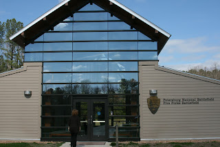
Our last stop was the Five Forks Battlefield. In this battle the Union forces were able to capture the South Side Railroad which was the last remaining rail line supplying Petersburg. The Union was led by Philip Sheridan. George Pickett was in command of the Confederates. It seems that at the time of the Union assault Pickett had withdrawn from the front lines to have a lunch of shad some two miles behind the lines. One of the Union leaders was George Armstrong Custer. The battlefield featured a new visitors center and some wonderful forest trails. We took a 1 1/2 mile hike to a pond that was a bird sanctuary.
One of the things we didn't do on this trip was to visit downtown Petersburg, which despite the siege and shelling still retains a number of Civil War era buildings including a Siege Museum and Farmers Bank Museum. The is a 68-stop auto tour of Civil War Petersburg that we'll catch next trip.
Tuesday, March 27, 2012
Sunday, March 25, 2012
Catching Up - Part I
For those 3 or 4 of you that actually check in on this blog, I apologize for not posting in awhile. We've been busy and I've been lazy. The combination is deadly to blogging. Since my last entry we've continued to explore the area, gone on Spring Break, and attended various cultural events. I've been singing with the Eno River Unitarian Universalist Fellowship choir and am beginning to develop some friendships. Jeff and Jane from Sommers, NY, are also recent relocaters to Durham. Jeff and I have jogged and chatted together once a week. He in much better shape than I, but has been very amenable to walking when I need to(which unfortunately seems to be much more often than in the past). I ran a race here in Durham this past Saturday and finished almost two minutes slower than last years time. Admittedly it was a different course and it was raining, but it shows I still have a lot of work to do.
On Spring Break we took the dogs and went up to Petersburg(no "h"), Va. and explored the battlefield sites around that city. The battle for Petersburg actually started in June, 1864 when General U S. Grant attempted to capture the city, which was a railroad hub, and thereby cut off the Confederacy's ability to supply Lee's army in Richmond. The battles for Petersbug turned into a nine month "siege" of the city, which was ended when General Philip Sheridan's forces defeated General Pickett's(yes the same General Pickett) at the Battle of Five Forks.
The Petersburg National Battlefield Park consists of several specific sites: Grant's Headquarters, the Eastern Front, the Western Front, Five Forks, the Home Front in downtown Petersburg and a 33 mile long drive which generally follows the siege lines. Along those lines, there are physical remains of forts and artillery batteries where you can stop and view the siege up close.
The start of our exploration was Grant's Headquarters at City Point. This cabin located on the Appomattox Plantation(see below) was built in November 1864. Up until that time Grant had lived in a tent. It was part of a series of 22 log cabins erected for Grant and his staff. Grant's wife and his son Jesse stayed with him in the cabin during the last three months of the siege which ended in April, 1865.
The Appomattox Plantation stands at the confluence of the Appomattox River and James River. It was the home of Dr. Richard Eppes and his family until 1862 when Union gunboats came up the James River and convinced Dr. Eppes to move his family into Petersburg. During the siege it served as the offices for the U. S. Quartermaster and his staff. It now serves as a museum and Park Visitor Center. If I remember the brief tour properly, the house remained in the Eppes Family until turned over to the Park Service. Most of the furniture in the two restored rooms comes from the family and is original.
The driving tour starts at the Eastern Front Visitor Center where on June 15, 1864 the Union forces started their attack on Petersburg. Five railroads lines passed through the hub of Petersburg and brought supplies from the South which were then forwarded to Lee at Richmond for that city's defense. Grant decided that capturing Petersburg would quickly cause Richmond to fall. The Confederates were dug in along a defensive perimeter called the "Dimmock Line" which contained a number of artillery batteries. Confederate Battery Number 5 was captured by Union forces on the 15th. Like so many other battles in the Civil War, the Union forces failed to follow-up on their initial positive results and push straight into Petersburg. As a result, the opposing forces 'dug-in' and the siege started.
From the captured Confederate Battery Number 5, Union forces were able to lob mortar shells into Petersburg and the Confederate positions beyond the Appomattox River. They did this with huge mortars such as "The Dictator" - pictured below.
At Confederate Battery Number 9 the Park Service has reconstructed examples of siege fortification. The site itself was a stronghold captured by Black troops on the first day of the battle and converted into a Union "fort".
Throughout this portion of the park are trails that take you along thoroughfares used by the troops to move supplies from railroad sidings to the front lines. We were there on a beautiful Spring day and were able to hike several miles. We managed to tire out ourselves as well as the dogs.
The last major site in the Eastern Front portion of the Park is the site of the Battle of The Crater. On July 30, 1864 Union troops exploded 4 tons of dynamite in a tunnel they had dug under the Confederate lines in an attempt to create a hole in the Confederate line.
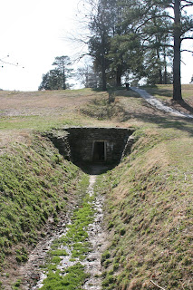
This section of the Union line was manned by miners from Pennsylvania. They hatched a plan to dig a tunnel to a point under the Confederate lines and then explode the TNT to cause the breach in the line that the Union could then pass through. This is the tunnel entrance where the miners started their tunnel.
As a kid I had a jigsaw puzzle which was based upon a painting of the Battle of the Crater. I had that picture in my mind as we approached The Crater. Much like my expectation regarding Devil's Den at Gettysburg, I found that actual site much smaller. It is hard to imagine that the union lost 4,000 men and the Confederates 1,500 in a space as small as the Crater.
Of course, over the years I assume much of the crater has filled in, but it still covers a relatively small area. Interestingly enough I recently read a Golf Magazine article about the fact that a golf course existed on this site until the 1930s. That course kept much of the military earthworks and used them as hazards.
We stayed in a dog-friendly motel which was just across the street and through the woods from the Crater site and in the morning were able to cut through the woods and visit the Crater on a still and beautiful Spring morning.
Subscribe to:
Comments (Atom)


